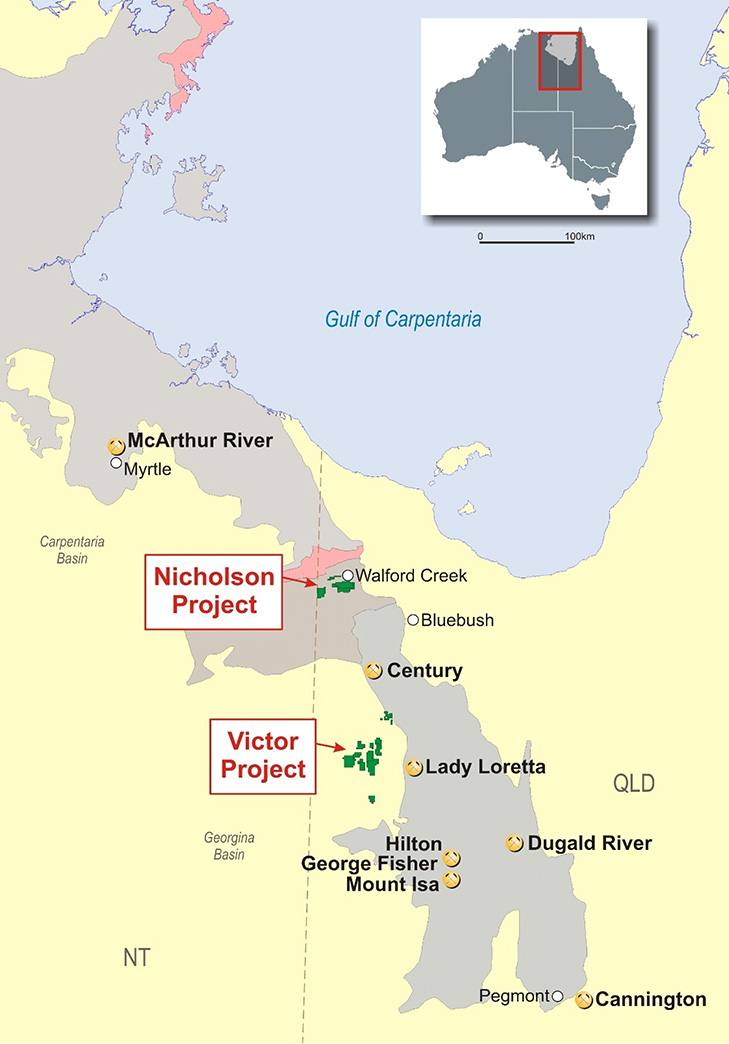
Major production from within the Province currently comes from McArthur River (zinc and lead), Mount Isa (copper, lead, zinc and silver), Cannington (silver and lead), Century (zinc, lead and silver) and Ernest Henry (copper and gold). A number of smaller mines are also in production.
Recent drilling by Superior (in joint venture with South32) at the Nicholson Project (EPM15670 and EPM18203), confirmed the presence of sediment-hosted lead-zinc-silver massive sulphide (SEDEX) deposits, similar to the Mount Isa and McArthur River deposits.
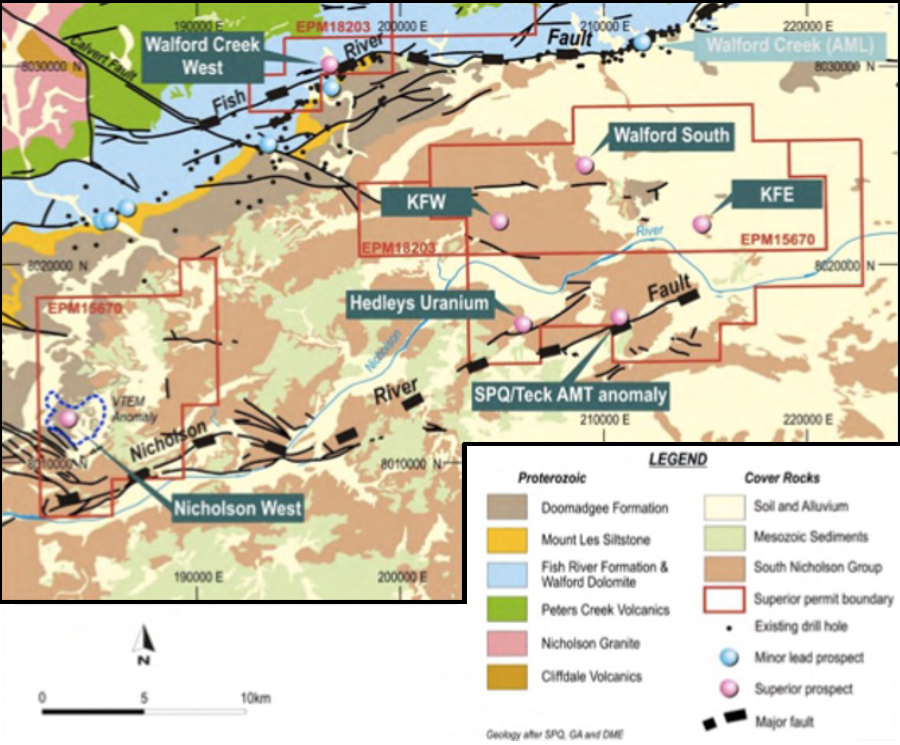
The project is located within a sequence of prospective Proterozoic sediments within the east-northeast trending Hedleys Graben. This graben is bounded by the Fish River Fault on its northern side and the Nicholson River Fault on its southern side.
Sediments of the Fickling Group within the Hedleys Graben are equivalent in age to sediments that host large base metal mineral deposits at Mount Isa and Macarthur River. In particular, the Mount Les Siltstone has potential for large stratiform base metal deposits at the Nicholson Project. The Doomadgee Formation which unconformably overlies the Mount Les Siltstone is also thought to be of similar age to the part of the Lawn Hill Formation which contains the large stratiform Century lead-zinc- silver deposit. All of these formations are target horizons in the Nicholson Project area.
Exploration work completed to date has identified at least eight large high priority geophysical targets, each of which have potential to be caused by Tier 1-sized stratiform base metal deposits. In addition, the project area also includes the Walford Creek West Zinc-Lead-Copper-Cobalt Prospect and the Hedleys Uranium Prospect.
High priority EM conductivity anomalies
An airborne VTEM (Versatile Time Domain EM) survey over 260-line kilometres of part of the Nicholson Project was completed by Geotech Airborne Pty Ltd in 2007. The original data was remodelled during late 2018 and interpreted by geophysical consultants, Aarhus Geophysics.
The applied Aarhus method is designed for detection and delineation of subsurface contrasts in conductivity and resistivity. In particular, the responses can be interpreted from the collected data to detect sub-surface accumulations of massive sulphide deposits.
Most of the conductivity targets that have been identified are of sufficient size to be a McArthur River or Century-sized deposit.
Drilling program – 2019
During the second half of 2019, under an earn-in and joint venture arrangement with global miner South32, Superior drilled four diamond core holes totalling 3,175 metres at three of the initial eight Aarhus-modelled target areas. Drilling at one of the highest priority targets at Nicholson River missed the target horizon and requires follow-up drilling. Due to the northern region monsoon season, only the Nicholson West and Nicholson River targets were drilled. Initial drilling at several other highest priority targets is yet to be conducted.
The drilling confirmed the presence of a SEDEX-style mineralisation system at the Nicholson West target area. Encouraging levels of zinc and lead mineralisation were returned, resulting in the interpretation that the drilling is likely to be located on the outer edges of a SEDEX system. The main body of mineralisation is likely to be developed closer to the potential mineralising feeder structure located about 3 kilometres to the south at the Nicholson River Fault Zone. Nicholson West is considered to represent the outer zones of a potentially mineralised apron of a large SEDEX system.
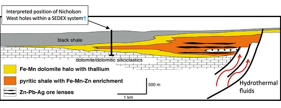
The Company considers that the 2019 drilling has upgraded the potential of the project to host a large base metal deposit. Several highest priority targets are yet to be drilled. South32 withdrew from the joint venture on 4 March 2020.
Walford South
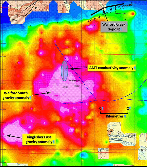
The Walford South target is a coincident VTEM and gravity anomaly with an associated audio-magnetotelluric conductivity anomaly (AMT). The anomalies are located adjacent to at least two significant fault structures that trend east-west and northwest-southeast.
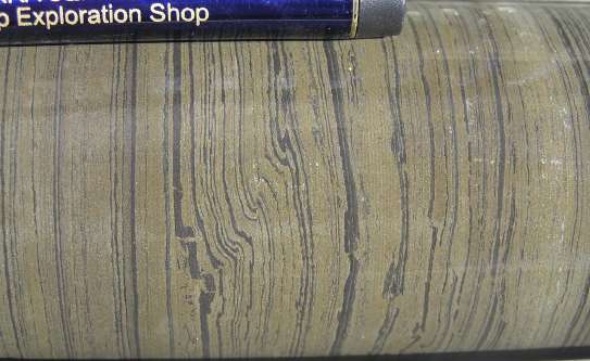
Previous historical drilling of three vertical diamond core holes by Superior intersected well-developed stratiform pyritic shale within the Mount Les Siltstone.
Geophysical data sets covering the Walford South prospect area indicates that a high order AMT conductivity anomaly may be associated with the significant northwest-trending fault. Aarhus VTEM and AMT modelling indicates that there has been downwards displacement of stratigraphy on the southwestern side of the fault.
Superior’s interpretation is that the northwest trending fault may have been a conduit that was feeding hydrothermal mineralising fluids that formed the stratiform sulphide mineralisation at Walford South. In this scenario, the AMT conductivity anomaly may represent a zone of copper-zinc-lead mineralisation, as occurs at the nearby Walford Creek deposit (held by Aeon Metals Limited), which is developed within and adjacent to the Fish River Fault.
The Walford South AMT target is a highest priority target. A diamond drill hole is being planned to test the AMT anomaly and northwest trending fault structure during the next drilling program.
